


This is the third of a 3-Part Series of articles where we describe some of the details of our Climb of Mt. Kilimanjaro. In Part A we covered the Gear we’re taking. In Part B we reviewed the Trip Logistics. In this segment we explain the Climbing Route, what we will encounter over this week-long adventure, and why Kilimanjaro is such a truly unique place.
****************
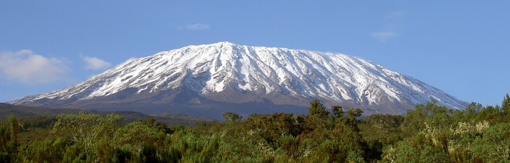
Have you ever thought of climbing Mount Kilimanjaro? The mountain has one of the most unique climatic environments on the planet and it is situated in one of the most compelling countries anywhere. During a six-day ascent of this über-volcano, climbers are privileged to walk through six distinct Climate Zones, each with unique plants, animals and ecosystems. There are also unique challenges at each stage of the journey. Here is an example of what we will see and do in less than one week on our ascent of the mountain, and the route that we have chosen, the Machame Route:
Day 1 (Jan31): Machame Gate (1634 m/5,363 ft) to Machame Hut (2834 m/9,300 ft).
Hike time: 8 hrs
Elevation change: +1200 m/+3937 ft
Estimated distance: 10km/6.21 miles
Final elevation: 3100 m/10,170 ft
We leave the town of Moshi, Tanzania and head to “Machame Gate” in Kilimanjaro National Park which is where the fun starts. It is illegal to enter the park without having hired a Guide and Porters. We will meet our Head Guide and our High Altitude Porters will start sorting through group’s gear. As Climbers, we will each take a daypack with 3 litres of water, our lunch, rainwear and some extra warm clothes for higher up. The Porters will take a week’s worth of food and cooking equipment for the team, all the tents and sleeping bags and communal gear in addition to their own gear. Similar to Napalese Sherpas, it is remarkable to see these guys carry 30lbs on their heads and they scamper like gazelles up the mountain. But this is what they do all day, every day.
From Machame Gate we hike for about 8 hours on well marked trails to our first camp. The first part of this day, we’ll be in the “Culitvation Zone” (2,600-5,900’) were we will have tropical conditions. An average of 45 inches of rain falls there each year. These lowlands are densely cultivated with coffee and banana plantations as we start walking. Soon we’ll enter the Rain Forest at around 5,900’. This zone receives the highest amount of rainfall, up to 78 inches per year! The moisture results in a belt of dense rain forest and mist. Brightly colored butterflies, toucans, and colobus monkeys can be found here. The average temperature should be around +25C so we’ll be hot and humid as we carry our packs. Rain jackets are a must and everything in our packs and duffle bags will be in water-tight bags. Sadly, due to the rain and cloud, we likely won’t see the forest for the trees (Hahaha!).
Day 2 (Feb1): Machame Hut (2834 m/9,300 ft) to Shira Hut (3749 m/12,300 ft)
Hike time: 7 hrs
Elevation change: +800 m/+244 ft
Estimated distance: 6km/3.75 miles
Final elevation: 3800 m/12,467 ft
After a 6AM start, we’ll be in the Health Zone at 9,200’, which is covered with heather and bright flowers. I’ll be snapping bus loads of photos here. Above the heath is a black Moorland where plants such as Lobelias and Gigantic 30’ Groundsels look like something from Jurassic Park. With no real trees, there are only a few Critters left in this zone. Winds will be noticeably higher so we will need to layer up with some jackets. It should be about +10C at this stage and we will likely still be in heavy cloud.
Day 3 (Feb2): Shira Hut (3749 m/12,300 ft) to Barranco Hut (3901 m/12,800 ft)
Hike time: 6 hrs
Elevation change: +100 m/+328 ft
Estimated distance: 6km/3.75 miles
Final elevation: 3900 m/12,800 ft
Here is where we start to feel life we brought a piece of Canada to Africa! We’ll be in the Alpine Desert zone from 13,100-16,400’. Harsh conditions prevail here. This zone is typically above the clouds so this semi-desert region receives less than 10 inches of rain annually. Temperatures here are normally around or below freezing and chilly at night. High winds are relentless and the fine dust permeates everything you have no matter how well you cover it up. This includes the hose of the hydration systems that we will carry (Platypus). Few plans can survive here, mostly just moss and lichen. Many describe this as a lunar landscape with strange volcanic forms everywhere. It will become noticeably harder to breath at this elevation so we will follow the Climber’s Mantra of “Climb High, Sleep Low”. On this day we will gain a bunch of elevation as we climb up to Lava Tower, a huge, remarkable volcanic rock formation, and then descend pretty much the same distance to camp low at Barranco Camp.
Day 4 (Feb3): Barranco Hut (3900 m/12,800 ft) to Karanga Valley (3963 m/13,000 ft)
Hike time: 4 hrs
Elevation change: +100 m/+328 ft
Estimated distance: 4km/2.5 miles
Final elevation: 3963 m/13,000 ft
As we will spend a few days traversing from the West to the East part of the mountain we will be gaining and losing elevation so that our bodies start producing more Red Blood Cells which will carry the lower amounts of oxygen to the muscles that we’ll need to carrying us upward, step by step, hour after hour, day after day. This is one of the reasons we picked this route as it is difficult but ideal for Acclimatization. Right after breakfast on Day 4 we will have to climb the dreaded Barranco Wall - a huge rock precipice that we will need hand and footholds to ascend. This is the steepest part of the trip, similar to a relatively easy grade of Rock Climbing, but without the ropes. We’ll need to be very careful here as the Barranco Wall is about 10 stories tall, and we will be working with less oxygen which will make it seem tougher. After the Wall, we will again descend to a lower elevation at our next camp which is relatively protected in a cool little valley.
Day 5 (Feb4): Karanga Valley (3963 m/13,000 ft) to Barafu Hut (4,600 m/15,091 ft)
Hike time: 4 hrs
Elevation change: +600 m/+1968 ft
Estimated distance: 4km/2.5 miles
Final elevation: 4,600 m/15,091 ft
Another relatively short day of ascending into the Alpine Desert Zone, and another day of high winds and cold temperatures in a moon-line landscape. This day will bring us all the way over to the east side of the mountain and up to our High Camp (Barafu). We will need to sleep during the afternoon in anticipation of a midnight departure for the top.
Day 6 (Feb5): Barafu Camp (4,600m/15,091 ft) to the Summit (5896 m/19,343 ft) and then back down to Mweka Camp (3100 m/10,170 ft)
Ascent time: 8+ hrs
Elevation change: +1300 m/+4265 ft
Estimated distance: 5km/3.2 miles
Final elevation: 5896 m/19343 ft
Descent time: 5-7 hrs
Elevation change: -2800 m/-9186 ft
Estimated distance: 12km/7.5 miles
Final elevation: 3100 m, 10,170 ft
We plan on making an “Alpine Start” at Midnight, which means that we will be climbing about 6 hours by the light of our headlamps. Fortunately we planned this trip to coincide with a full moon, which should be Epic! This will be a looong, and hopefully rewarding day in the Arctic Alpine Zone, above 16,400’. It’s an icy wasteland, baked by fierce sunshine during the day and frozen at night (Good!!). The weak air pressure here means that our lungs need to work twice as hard to get the oxygen they need to keep our bodies working (Woohoo!). Most climbers report serious headaches at this altitude (Bring it). Sleeping, eating and drinking become very difficult and our energy will be sapped (I Love it!). We’ll all need to borrow from Scott’s Iron Will here! This is also where the glaciers are so it will be very, very cold: -15C at best. We plan on wearing all layers of our clothes here, including two pairs of mits, down coats and balaclavas.
After all that exhausting work getting up, we should have just enough energy to snap some photos and drink in the view from the Roof Of Africa as the sun rises over the Indian Ocean and treks across the great Serengeti to Lake Victoria and beyond. But we can’t relax, because we need to get down from this altitude soon. The descent will be quick as we can “ski” through all the loose shale that we trudged up earlier, making our way back to our high camp for some food and water before descending even further on a different trail system called the Mwenka Trail. This is a steep trail that is only used for descending so as long as we have some gas left in the tank we should arrive at our last camp around dusk. This will make for a very long, hard day.
Day 7 (Feb6): Mweka Hut (3100 m/10,170 ft) to Mweka Gate (1828 m/6,000 ft)
Descent time: 4 hrs
Elevation change: -1250 m/-4101 ft
Estimated distance: 10km/6.21
Final elevation: 1828 m/6000 ft
I read somewhere that this is the most beautiful part of the trip. The Rain Forest is spectacular, the vegetation is beautiful and the views over the African Plains are surreal. I fully expect, however, that this point of our trip we will have mixed feelings: We’ll likely be relieved that all the exertion and knee-jarring punishment is nearly over, but also wishing that this wild, exotic adventure was not yet over. By the time we arrive at Mwenka Gate we should be thoroughly spent, welcoming the Land Rovers that will return us to Keys Hotel in Moshi, some clean clothes and lots of cold beer.
Hopefully this puts things into perspective, particularly for the many people who have been asking us about what things will be like. We just may get back after this trip and realize that we were way off on some of these key points, or we may end up returning after having made it no higher than the first camp - time will tell. One thing is for sure, with less than a week to go until the plane’s wheels touch down on a Tanzanian soil, we already having an amazing time researching, training, getting kitted up and meeting so many awesome people who are willing to help us with guidance and donations for cancer.
Which reminds me, if you have not donated, please take a moment to do so. Even just a couple of dollars will help. If you can’t donate, please help us spread the word. We are only a few days away from leaving and we are so very, very close to realizing our fundraising goal. Join us in our efforts to Do Something Big!
Asante sana!
Terry
We certainly do wish you good Luck on reaching your goal.
ReplyDelete